 "facw" (facw)
01/20/2018 at 01:12 • Filed to: Crash, US-59
 2
2
 8
8|
"facw" (facw)
01/20/2018 at 01:12 • Filed to: Crash, US-59 | 2
| 8 |
Looking at Google Earth I came across this:
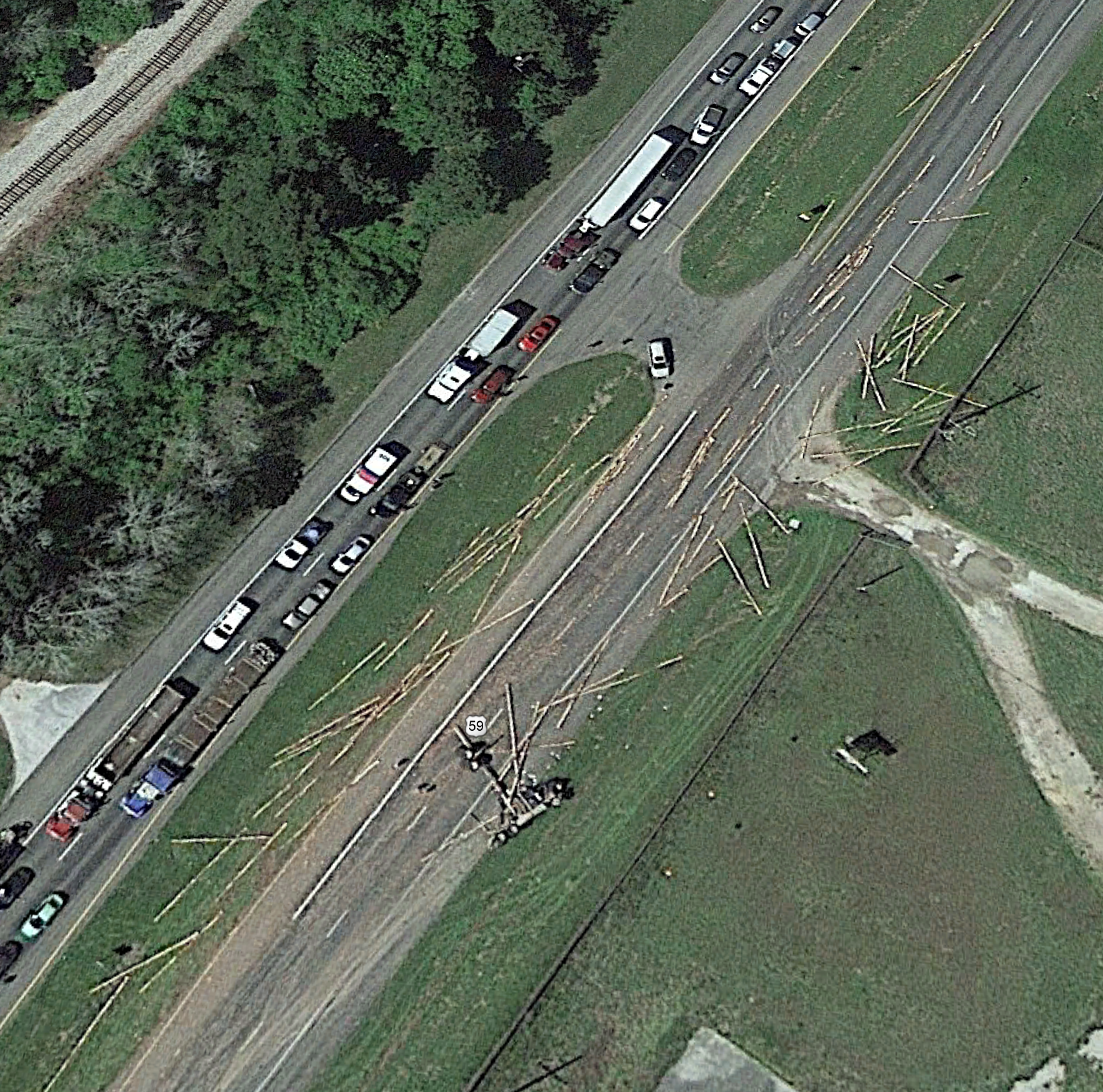
which I thought was kind of amazing. Sadly just to the south, there’s a car that looks pretty much obliterated, this was probably a fatal accident. There’s several other vehicles that look like they may have been involved as well (including a truck that is blocking all the southbound traffic), though none of them have obvious damage. Terrifying to think of what it must have been like to have that cargo come loose at speed. Looks like the farthest pole/log/tree trunk/whatever ended up around 900ft from the spot of the initial accident.
 Dusty Ventures
> facw
Dusty Ventures
> facw
01/20/2018 at 01:43 |
|
Where is this?
|
facw
> Dusty Ventures
01/20/2018 at 01:49 |
|
Just north of Shepherd, TX on US 59. https://www.google.com/maps/place/30°31'51.4"N+94°58'32.1"W/@30.5308449
 pip bip - choose Corrour
> facw
pip bip - choose Corrour
> facw
01/20/2018 at 01:53 |
|
Someone had a very bad day
 sm70- why not Duesenberg?
> facw
sm70- why not Duesenberg?
> facw
01/20/2018 at 02:44 |
|
Those coordinates are in the ocean just of the coast of Ghana
|
Dusty Ventures
> facw
01/20/2018 at 02:50 |
|
Can’t find any news articles on it. Wish I knew what year the image was from
|
facw
> sm70- why not Duesenberg?
01/20/2018 at 02:53 |
|
That’s weird. Let’s try that again: https://www.google.com/maps/place/30%C2%B031'51.4%22N+94%C2%B058'32.1%22W
|
facw
> Dusty Ventures
01/20/2018 at 02:55 |
|
Google Earth said 4/2/2017, though I don’t think those dates are always accurate. I couldn’t find any stories on it when I looked.
 Ash78, voting early and often
> facw
Ash78, voting early and often
> facw
01/20/2018 at 08:19 |
|
If logging trucks aren’t dribbling sap all over your car on the highway, they’re spilling guant shrapnel all over the place. They scare me more than any other vehicle on the road because the loads have almost zero security.